Tuesday, November 3, 2009
Routeburn Track
The Routeburn Track is one of NZ's officially designated 'Great Walks'. It's a 3-day one-way trail through bush and alpine mountains in the Mt Aspiring National Park.
NZ is all about the outdoors, and we decided early in the trip that we ought definitely to walk one of the multi-day Great Walks before we left. The Routeburn came highly recommended and seemed ideal, as it can be accessed by shuttle bus to/from Queenstown.
So, we booked the overnight stays in the DoC (Department of Conservation)-run huts, arranged our transport to/from the trailheads at the Routeburn Shelter and The Divide, and rented a few necessary bits of gear for the hike. We also stocked up on nut bars, porridge oats and dehydrated meals (yum!).
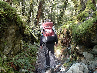
On day 1, we were very lucky to find the weather perfectly clear - without it being too hot. We set off from the Routeburn shelter in high spirits. The first part of the track leads through beech forest, an important (and protected) natural habitat for several native species.
The going was good as we stopped for lunch at the Routeburn flats, admiring the great view back down the valley. Still with loads of energy, we started up the steep climb towards Routeburn Falls, where we were to spend our first night.
That was when the views started getting really awesome. As we climbed higher, the view just got better and better, and as we crossed a slip where a 1994 landslide has removed some of the forest, were treated to an incredible scene; the flats spread out below with the snow-capped peaks looming overhead.
We arrived at the Routeburn Falls hut in plenty of time, allowing us a look at the falls themselves just above the hut and get plenty of rest. We were welcomed by the impressively friendly and helpful John, the DoC hut warden.
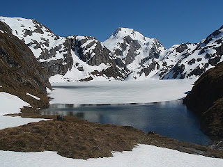
The real excitement was in store for the next day though! The Great Walks peak season has only just started, and there's still plenty of snow on the alpine section of the track. That means avalanche danger: pieces of snow ranging in size from a microwave up to a kitchen table can break off the slowly melting snow and fall onto the track at any time. This happens silently and without warning. Any chunks that might hit a person walking the track would be about as hard as concrete. Needless to say, that could be very dangerous! In previous years, DoC have closed the track when there's a risk of avalanche, but this year they've decided to provide alternative transportation through the Alpine section: helicopter!
For a bargain (i.e. subsidised) price, we got an impossibly scenic flight through the mountains. It only lasted about 2 minutes, but we were nevertheless extremely chuffed! From her front seat, Rachel managed to shoot a quick video as we took off over the frozen lake.
This did mean that we arrived at the next hut, at Lake MacKenzie, rather early, so we had to adjust our itinerary. We continued on for the rest of day 2 to stop for the night at Lake Howden hut (run by another friendly, helpful John) and even had time, after dropping our packs at the hut, to hike up the side track to Key Summit, taking in the views of glacial tarns and hanging valleys.
On the third day, the break in the weather sadly closed, and the clouds came right down to the Howden hut, around 700m above sea level. Fortunately, we only had a few km left to hike out to meet the bus at The Divide. We climbed into the bus feeling very tired but thoroughly pleased with ourselves!
Just to prove that it really was tough, here's a picture of me having to wash my feet in near-freezing glacial water!
Rob
Subscribe to:
Post Comments (Atom)


No comments:
Post a Comment