Friday, November 27, 2009

Goodbye NZ!


Our last weekend in New Zealand was packed with great day trips and birthday celebrations. My dad, Rob and I took a short ferry trip to Rangitoto, a volcanic island in the Hauraki Gulf.


Rangitoto appeared out of the sea after a series of erutions about 600 years ago. It must have been a shock for the Mauri people living on adjoining Motutapu island! The lower slopes are still bare lava rock, so our picnic spot was quite uncomfortable!


The view from the summit was amazing - you can see right across to the city and, on the other side, as far as the Coromandel Peninsular. There are some lava caves at the top of the island, which were formed by a crust of lava cooling and the hot lava inside flowing out to leave a hollow.


Another day, another island... for my birthday day out we all went to beautiful Waiheke, yet another little gem just a short hop from Auckland.


We visited Mudbrick, a fantastically located restaurant with amazing gardens and spectacular views across to Rangitoto.


It was lovely to spend my birthday with Mum and Dad. Last year we celebrated with our adopted family and friends in Panama and, as enjoyable as that was, I did miss having them around.


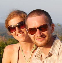
We also had one last catch up/ goodbye/ birthday celebration with our Auckland friends. Coffee with Kandace on my birthday and a night out with (below) Mark, Jen and Mark's brother, Phil, in Ponsonby. We were very sad to leave them all but all promised to stay in touch and hope to meet up again somewhere in the world!


Then the really tough farewells. We flew out from Auckland at 1am on 10th November so, late on my birthday, after a delicious meal, we all left for the airport. It was very hard to leave Mum and Dad behind, knowing I wouldn't see them again for another year, so there were lots of tears. On the other hand, they've created a great life for themselves in New Zealand, with a much more relaxed pace, lots of nice friends and more fantastic places to visit.


The journey back was quite enjoyable. It was very long (10hrs to Singapore, where we had a shower to refresh ourselves for the second leg, then 14hrs back to London) but we had amazing views some of the way, like this one over the mountains of Afghanistan.


As you would expect for mid November, the weather was very miserable when we landed at Heathrow. The palette of turquoise, blue and green of our last few days in NZ was gone and in its place was... well, grey, really!

We've now been back for about 2 weeks and are settling back into UK life. I've been getting some days of supply teaching work while Rob gets on with the serious business of job searching. It looks like we'll be based somewhere down south and we'll certainly be in the UK for a good while now, but don't worry, we won't stop exploring our amazing planet just yet!

Rachel x

Thursday, November 19, 2009

Leaving the South Island


As our time in the South Island came to an end, we headed back up the East coast towards Christchurch, where we were to drop off the campervan. On the way, we called in to see one of the South Island's most famous sights.


The Moeraki Boulders are an amazing collection of spherical rocks, seemingly dropped out of thin air onto the beach at Moeraki, near Oamaru. According to geologists, they were formed when crushed seabed matter (such as shells) coalesced around small lumps of harder rock, which was then made larger (and round) by marine creature action (similar to worm action). Minerals in the rock then chemically reacted, causing the core to shrink, in turn causing the outer rock to crack. The cracks were back-filled with more (different) rock, giving the lines that can be seen on the surface of the boulders.


After marvelling at the boulders, we had just one stop left: Christchurch.


Christchurch is the most English of NZ's cities. Looking at the street names (including, we were pleased to see, Lichfield St!) you can certainly see the English influence. The weather was fantastic, so we fully enjoyed the botanic gardens.


A nice way to see the city is to use the restored tram system. It's stricly for tourists only though, as it only runs a 2km one-way loop around the centre! It's very relaxed, and there's an accompanying tour commentary.


We had a really nice, relaxed time in Christchurch, perfectly rounding off our time in the South Island, before we headed to the airport for our return flight to Auckland.

Rob

Saturday, November 14, 2009

Tiki's Tours


We had some great adventures in our camper van, which we named Tiki. We loved the freedom that it gave us and the "off the beaten track" spots that we could visit on our own four wheels.


We camped in some great places with Tiki...


Sunny mornings and mountain views in Wanaka


and right on the beach in sleepy Gore Bay. The only problem was, at first, we found it almost impossible to do any "freedom camping", so were having to go to proper camp sites every night. Here's Rob with one of the dreaded "No Camping" signs that were so common around Marlborough and Nelson.


Fortunately, as we moved on, we found more and more beautiful spots to stop at the side of the road, like this one over-looking Arrowtown and Queenstown,


and high up on the Otago Peninsular with all the bays and headlands spread out beneath us.


Heavy rain meant that this camping spot near Blenheim was dangerously close to the river and we had to make a dash for higher ground in the middle of the night!


This was a great spot in stunning Fiordland where, the following day, we woke to snow on the roof.


After exploring the South Island together for over a month, we were sad to say goodbye to Tiki and take her back to Christchurch. We took one final photo of the three of us.

Rachel x

Wednesday, November 4, 2009

Penguins!


We've been really lucky in the last week or so and seen three different types of penguins! Unfortunately they're very shy creatures so photos had to be taken from a long way away and, in one case, not at all! Apologies for poor quality of pictures.


First was the Fiordland crested penguin in Milford Sound. This little guy has a great hair cut and seemed to be enjoying hopping about on the rocks.


While visiting the gorgeous Otago Peninsula near Dunedin, we spent an hour or so camped out in a hide on Sandfly Bay (mercifully free of them that evening!) near a yellow eyed penguin colony. This one was slowly clambering his way up the steep cliff back to his nest just above the beach. His little legs meant that after a just few quick waddles he had to stop for a break.


We loved Sandfly Bay, it had a very special atmosphere, with huge sealions lounging around on the beach and lots of birds enjoying the peace and quiet. On our way back across the sand, we spotted another penguin leaving the water and on its way back to its nest.


Our last penguin spotting event was a trip to Oamaru Blue Penguin Colony on the East Coast. This is home to little blue penguins who, weighing only 1kg and measuring around 30cm in height, are the smallest and rarest penguins in the world. Seeing them was a really special experience; we arrived just as the sun was setting and took our places on the special penguin viewing platform. As it got darker, the guide pointed out "rafts" of around 50 little blue penguins drifting across the water towards the beach. After a few failed attempts to escape the fierce surf, they all flopped onto the rocks, scrambled up the cliff and ran to their nests. We even saw some chicks coming out to meet their parents! Altogether 189 penguins came ashore that night (there was an official count for monitoring purposes) and we felt really priveleged to see such unique birds in their natural environment. OBPC is a really good organisation and does everything it can to limit human interference with the colony, which explains why the only photo we have is of me with a giant limestone penguin!

Rachel x

Tuesday, November 3, 2009

Routeburn Track


The Routeburn Track is one of NZ's officially designated 'Great Walks'. It's a 3-day one-way trail through bush and alpine mountains in the Mt Aspiring National Park.


 NZ is all about the outdoors, and we decided early in the trip that we ought definitely to walk one of the multi-day Great Walks before we left. The Routeburn came highly recommended and seemed ideal, as it can be accessed by shuttle bus to/from Queenstown.


So, we booked the overnight stays in the DoC (Department of Conservation)-run huts, arranged our transport to/from the trailheads at the Routeburn Shelter and The Divide, and rented a few necessary bits of gear for the hike. We also stocked up on nut bars, porridge oats and dehydrated meals (yum!).


On day 1, we were very lucky to find the weather perfectly clear - without it being too hot. We set off from the Routeburn shelter in high spirits. The first part of the track leads through beech forest, an important (and protected) natural habitat for several native species.


The going was good as we stopped for lunch at the Routeburn flats, admiring the great view back down the valley. Still with loads of energy, we started up the steep climb towards Routeburn Falls, where we were to spend our first night.


That was when the views started getting really awesome. As we climbed higher, the view just got better and better, and as we crossed a slip where a 1994 landslide has removed some of the forest, were treated to an incredible scene; the flats spread out below with the snow-capped peaks looming overhead.


We arrived at the Routeburn Falls hut in plenty of time, allowing us a look at the falls themselves just above the hut and get plenty of rest. We were welcomed by the impressively friendly and helpful John, the DoC hut warden.


The real excitement was in store for the next day though! The Great Walks peak season has only just started, and there's still plenty of snow on the alpine section of the track. That means avalanche danger: pieces of snow ranging in size from a microwave up to a kitchen table can break off the slowly melting snow and fall onto the track at any time. This happens silently and without warning. Any chunks that might hit a person walking the track would be about as hard as concrete. Needless to say, that could be very dangerous! In previous years, DoC have closed the track when there's a risk of avalanche, but this year they've decided to provide alternative transportation through the Alpine section: helicopter!


For a bargain (i.e. subsidised) price, we got an impossibly scenic flight through the mountains. It only lasted about 2 minutes, but we were nevertheless extremely chuffed! From her front seat, Rachel managed to shoot a quick video as we took off over the frozen lake.


This did mean that we arrived at the next hut, at Lake MacKenzie, rather early, so we had to adjust our itinerary. We continued on for the rest of day 2 to stop for the night at Lake Howden hut (run by another friendly, helpful John) and even had time, after dropping our packs at the hut, to hike up the side track to Key Summit, taking in the views of glacial tarns and hanging valleys.


On the third day, the break in the weather sadly closed, and the clouds came right down to the Howden hut, around 700m above sea level. Fortunately, we only had a few km left to hike out to meet the bus at The Divide. We climbed into the bus feeling very tired but thoroughly pleased with ourselves!


Just to prove that it really was tough, here's a picture of me having to wash my feet in near-freezing glacial water!


Rob